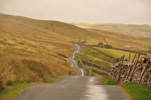
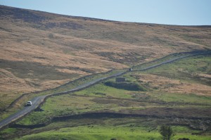
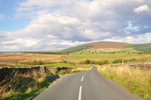
 This 46 mile drive takes in some spectacular natural attractions, travelling close to Malham’s tarn and limestone pavement and the 2000 foot peak of Pen-y-Ghent. It also contrasts some of the Dales most visited locations, such as Skipton and Burnsall, with some of its most remote and hard to access, like the tiny hamlet of Halton Gill at the head of Littondale. Its a varied route, showcasing come of the best scenery in the Dales within a timeframe of a couple of hours with some short stops.
For some unique photographic perspectives of the Dales and villages covered by this drive , have a look at our sister website- Yorkshire-Photography.com.
Start Skipton
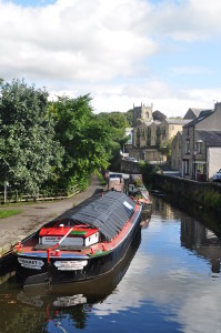 By the standards of the Yorkshire Dales, Skipton is a metropolis with over 14,000 residents. It’s a market town, located on the River Aire and the Leeds and Liverpool Canal just south of the Yorkshire Dales, 16 miles northwest of Bradford and just off the A65 Road. The town grew around Skipton Castle, constructed originally with a wooden keep in 1090 by Robert de Romille, a Norman baron. In the 12th century William le Gros strengthened the keep with stone, and today the castle is one of the most complete and best preserved medieval castles in England giving excellent views over the surrounding area.Skipton’s history is intrinsically linked to the trading of sheep and woollen goods. Its name is derived from the Old English sceap (sheep) and tun (town or village). It became a prosperous market town and the woollen trade increased in the 18th century with the arrival of the Leeds –Liverpool canal. This 130 mile stretch of water was one of the marvels of the industrial revolution, and Skipton is close to its Northernmost point. Today the canal is still a focal point of the town, with many brightly decorated canal narrowboats to be seen moored in the centre of town. Skipton retains its essentially Norman layout dominated by the Castle, the parish church, and traditional cobbled market place with from which run passageways or ginnels, which were originally narrow medieval landholdings known as tofts and crofts. Today these are busy pedestrian thoroughfares containing shops, pubs and cafes.
Pick up the main A65 road heading North towards Gargrave. Its a busy, and fairly fast stretch of road, when compared to most other roads in the Dales.
Gargrave sits on the main A65 road and also on the River Aire and Leeds-Liverpool Canal, and the railway line North towards Cumbria from Leeds and Bradford. It’s therefore an important transport hub in the Craven area. It’s a sizeable settlement in the area with around 1800 inhabitants and has the feel of a small town rather than a village. Half a mile south of the village are the remains of a Roman Villa, called Kirk Sink. The stones used to construct the villa were gradually removed and most likely used to make the present village church. Also, on West Street in the village the remains of a moated dwelling from the 13th century has been found. In 1774 the canal arrived in the village and by the 18th century there were a number of cotton mills in the village which took full advantage of the proximity of the canal and its links to the major industrial cities of the North. Gargrave has a number of accommodation options, plus some cafes and 3 pubs –The Masons Arms across the bridge near the church, the Old Swan on the main road in the village and the Anchor on the canal at the edge of the village.
Follow the road through Gargrave for a couple of miles, through some rather uninspiring farm land ,under the railway line and cross the River Aire before you reach Conistone Cold.
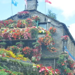 Coniston Cold is a small village of around 186 inhabitants on the A65 North of Gargrave. It’s famous for its ‘Swiss Flower House’ owned by local residents Anne and Robin Strange who maintain a colourful floral display at their home on the main A65 road. It’s a well know splash of colour along one of the busiest, and some may say dullest, stretches of road in the Dales.
At Conistone Cold, take the un-named road to the right, signposted Malham and Bell Busk. This small lane is the perfect antidote to the traffic-heavy A65 as it runs alongside the River Aire and passes under the railway again, before arriving at a junction by a stone bridge over the river, with a left turn to Bell Busk and a right turn, over the bridge to Airton and Malham. Take this right turn. Cross the bridge and take the road on the left. Follow this road for around a mile and a half to a T Junction. Take the left turn signposted Airton and Malham. Follow the road between hedgerows to arrive at Airton.
Airton is a hamlet of 175 permanent residents on the road between the A65 and the tourist honeypot of Malham. It’s a quiet place with no pub or post office. Its main attractions are an old mill on the River Aire, a Quaker meeting house and a Tea Room at Town End farm.
Follow the road through the village and on to arrive at the bridge in Kirkby Malham, next to The Victoria pub.
Kirkby Malham is a small village in Malham Dale. Its church, St Michaels is a Grade I listed building. A church has originated on the site since the 7th or 8th centrury but the current building dates from the 15th century with extensive rebuilding taking place in the 18th and 19th century. The American author Bill Bryson moved to the village in the late 80’s having left a journalism job and it was there that he began his successful travel writing career.Bryson has referenced the village in his books and has been quoted as saying “I won’t know for sure if Malhamdale is the finest place there is until I have died and seen heaven but until that day comes, it will certainly do.”
The road winds its way through Kirby Malham before climbing Kirkby Brow, after which the landscape opens up before you to give some great views of Malhamdale. The road widens before passing the National Park centre at the outskirts of Malham.
 Malham is a small village of around 150 inhabitants but is one of the most popular Dales villages, and on a summer’s day, visitor’s cars line the lane into the village. The Pennine Way passes Malham and it’s popular with walkers wanting to explore its nearby natural attractions. Malham Cove and its amazing Limestone Pavement are Yorkshire icons. Situated 1 KM North of the village, it is a large, curved limestone cliff at the head of a valley, and at the top is an area of Limestone pavement affording great views down the valley. The surrounding cliffs are popular with climbers – not recommended viewing if you’re scared of heights. Further North lies the glacial lake of Malham Tarn, at 377 metres (1,237 ft) above sea level; it’s the highest lake in England. From here, the Roman Road of Mastilles Lane heads East towards Kilnsey in Wharfedale. Closer to Malham village is the waterfall and popular swimming hole of Janet’s Foss, situated in a pleasant woodland glade. Past Janet’s Foss is Gordale Scar, a spectacular twisting gorge between limestone cliffs. Malham has two pubs, The Buck Inn and The Lister Arms, and both offer accommodation.
From Malham, two roads head North and either can be taken- they both converge again West of Malham Tarn after climbing out of the village.
The road to the left, Cove Road provides great views of Malham Cove over to the right.
 The right hand road crosses the bridge. You then need to take a left turn up Malham Raikes, signposted Malham Tarn. This steep road doesn’t provide such good long distance views of Malham Cove, but it does provide easier walking access to the limestone pavement. It also offers great views back down the dale. Follow the tarmac track and take the left turn at a cross roads (other road a dirt track) , signposted Malham Tarn and Settle. This long, narrow track runs along the plateau of Malham Cove with Malham Tarn over on the right. Eventually you arrive at the cross roads where the other road from Malham converges with this one.
At the Cross roads, take the road signposted Langcliffe and Settle (a left turn if you took Cove Road, straight on in you came via Malham Raikes)
Keep following the road, as it runs along the grassy lower flanks of Malham Moor with the distant Pen-y-Ghent coming into view to the front right.  Where the road swings left signposted Langcliffe and Settle, take a right and carry on until the road drops into a valley before climbing to meet Goat Lane with a signposted right turn towards Halton Gill . This is our route, but you may want to take a left turn to visit Stainforth a couple of miles down the lane.
The hamlet of Stainforth, is situated to the east of the River Ribble with Little Stainforth to the west, across a 17th century pack horse bridge which was once an important stopping point on the packhorse route through the dales between Lancaster and York. The village sits beneath Stainforth Scar, 2½ miles north of Settle and 3 miles south of Horton-in-Ribblesdale, and is the sight of Stainforth Force waterfall, close to the bridge.
Taking the right turn at Goat Lane, pass the farm buildings and follow the narrow lane uphill with some great views of the 2277 feet peak of Pen-y-Ghent eventually appearing on the left, with Fountains Fell to the right. The lane joins the Pennine Way and continues to climb through an exposed moorland landscape, passing the isolated buildings of Pen-y-Ghent House farm. Eventually the scattered cottages of Halton Gill come into view nestling beneath the fells ahead. A glance to the right provides great views down Littondale.
Halton Gill is a tiny village at the head of Littondale. The name means a farmstead in a narrow valley, haugh and gill both mean narrow valley. 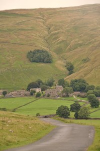 The small village nestles in the valley beneath steep hills and is a very picturesque, if isolated spot.An 18th century curate in the village Rev Miles Wilson, wrote abook to explain astronomy to the villagers, in which he imagined a cobbler climbing to the moon from the top of Pen-y-Ghent, and exploring the solar system. With its isolated position, Halton Gill is probably one of the best places in the UK to see stars on a clear night, which may explain the curate’s interest!
Follow the road as it bends round to the right and crosses the second stone bridge with signpost to Litton (2 miles) and Arncliffe (4.5 miles). Follow the lane as it begins to head South into Littondale, through some classic Dales scenery as it travels along the valley parallel to the River Skirfare, to arrive at the village of Litton.
Litton is a small village further which gives its name to the dale in which it sits. It has a traditional 17th century pub, the Queens Arms, and offers walking access over the hills to Buckden in the East and Pen-y-ghent in the West. Most of Litton lines the road, the Queen’s Arms, the Post Office, the old post office, farm houses and their converted barns. Old Litton lies beneath the waterfall South of the village and now comprises of only one habitable cottage.
Follow the narrow lane out of the village and between drystone walls as it proceeds along what’s arguably one the most photogenic of the Dales. Eventually the road bends right to enter Arncliffe. (though the road straight ahead carries on at this side of the river, through the hamlet of Hawkswick to also arrive at our destination , the B6160 near Kilnsey)
 Arncliffe is a small village of stone cottages around a pretty village green, situated in the valley of Litton dale around 3 miles from Kilnsey crag. Its church, St Oswalds is by the River Skirfare, which is crossed by a stone bridge. A steep climb takes you over Park Scar and down into Kettlewell and affords some fantastic views en route. The Falcon Inn in Arncliffe was the original ‘Woolpack’ Pub in TV soap Emmerdale, when it was still known as Emmerdale Farm.
Both roads running down Littondale through some great scenery with the slopes of Park Scar to the left. Eventually arrive at the B6160. Turn right here and head towards Threshfield, passing through Kilnsey with its famous crag en-route.
Kilnsey is a small village on the B6160 road, between Threshfield and Kettlewell. The village is famous for its large limestone cliff, Kilnsey Crag, overlooking the road and the River Wharfe from the west.  The Crag is around 170 feet high, with an overhang of 40 feet and is popular with climbers who can usually be seen dangling precariously as you pass along the road under the cliff. The village is set back off the road, behind the Tennant Arms pub, a 17 century coaching inn. Through the village, the road climbs to become Mastilles Lane which was a Roman Road and later a medieval drover’s route leading to Malham Tarn in the West. Walkers are afforded fine views of the village, the lakes of its trout farm and the surrounding countryside from a gate above the village where the road becomes a track. The Old Hall in Kilnsey was a medieval administrative site for the wool trade. Most of the present building dates from 1658. Kilnsey hosts a well know agricultural show on the Tuesday after August Bank Holiday It is one of the larger agricultural shows in the North of England and it attracts visitors from throughout the Dales and way beyond.
Follow the B6160 to Thresfield with the River Wharfe on the left. Just past the garage in Threshfield, take a left signposted Grassington, then a quick right to re-join the B6160, signpostd Burnsall. Follow the B6160 as it passes under a railway bridge and pas the right turn for Linton, which is worth turning off the road to visit.
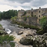 Linton is one of the most picturesque of Dales villages. Set just off the B6160 the village is set around a village green surrounded by an historic almshouse, a pub, the Fountaine Inn, and three stone bridges over its beck. North of the main part of the village is Linton Falls, a row of stone cottages set by spectacular falls cascading over erratic limestone formations. A 14th Century packhorse bridge, ‘Little Emily’s Bridge’, crosses the falls and heads up the field to the car park at Grassington. A few minutes’ walk from the falls is Saint Michael and All Saints church, on the banks of the River Wharfe as it flows towards Burnsall. The river can be crossed at most times of the year at this point via stepping stones
Continue on the B6160 to Burnsall, past the right turn to the hamlet of Thorpe and with the slopes of Burnsall Fell appearing to the right. Eventually the road drops down into Burnsall.
Burnsall is situated on the River Wharfe in Lower Wharfedale, and its five-arched bridge over which the Dalesway passes, is a much photographed Yorkshire icon. The village is situated between Bolton Abbey and Grassington and sits in a picturesque valley, with great views of the village from the road as you approach from Bolton Abbey and on the hills looking down upon it. The 2001 Census quoted a population of only 112, but the village has a church, a chapel, a primary school, two hotels with restaurants, and a pub. With its village green facing the river, Burnsall is generally classed as ‘The Dales’ to the people of Leeds and Bradford and can get quite busy on a Summers day. Most maps won’t highlight a campsite but a farmer does allow camping on his land – on the road from Grassington and the farm is a right turn near the Church Hall.
From Burnsall the B6160 climbs steeply up the dale giving great views back to the village and along the valley. The road passes Barden Tower at the peak of a hill.
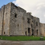 The 15th century ruin of Barden Tower on the B6160 was once a hunting lodge for the Lords of Skipton and the Earls of Cumberland. For 40 years it was the home of Henry, the 10th Lord of Skipton, who preferred the seclusion of Wharfedale to his main home at Skipton Castle. Henry was known as the Shepherd Lord because, as a child, he was sent into hiding with Shepherd families during the Wars of the Roses. The tower had fallen into disrepair by the late 1600’s and by 1800 its roof had been stripped of lead, leaving the ruin still visible from the road today.
Just after the tower, look for a minor road to the right, signposted ‘Embsay Dales Railway’. Take this right turn. On the moors to the right are Upper and Lower Barden reservoirs. The good, two lane road passes provides some great views looking back to Wharfedale to the rear , before bending round to deliver a panoramic vista of the countryside bordering the A59 as it heads towards Craven Dale. The road then passes through Eastby before arriving at Embsay.
Embsay, together with its neighbour Eastby form the civil parish of Embsay with a total population of 1,758. The village sits to the South of Embsay Crag and Barden Moor, which is popular with walkers and those participating in grouse shoots. It’s also close to two high isolated reservoirs Upper Barden and Lower Barden. Embsay station is the home of The Embsay & Bolton Abbey Steam Railway. The line was part of the former Midland Railway route from Skipton to Ilkley which closed in 1965 and today runs over a distance of 4 miles (from Embsay via Draughton Sidings, Holywell and Stoneacre Loop to Bolton Abbey station. The railway owns a number of steam locomotives, the oldest being ‘Annie’ built in 1908, and Steam train rides are available to the public every Sunday, with increased Summer services up to 7 days a week.
From Embsay follow Skipton Road back to reach the A65 and Skipton.
Circular walks which can be completed in conjunction with this drive-
Follow DriveTheDales and 54°North Photography on Social Media

